When it comes to UAV aerial mapping or drone surveying, “close” doesn’t cut it. Today’s technology has upped the ante on what can be done from a UAV, how quickly, and with what level of precision. And there’s no putting the genie back in the bottle.
Centimeter-level accuracy can now be yours from almost anywhere in the world using direct georeferencing and global GNSS correction technology that simplifies the entire mapping workflow. Map data can now be ready in the air or shortly after the UAV lands with a push of a button, eliminating time-consuming base station requirements or superfluous steps.
More data = greater accuracy = better product
The integration of GNSS and inertial sensors in an aided-inertial navigation system (aided-INS) for direct georeferencing (DG) is becoming a new standard for high-accuracy airborne mobile mapping. Combining DG with camera and LiDAR technology that’s small and light enough to fit onto a drone has moved the goalposts closer for companies needing a quick, easy, fast and accurate mapping solution.
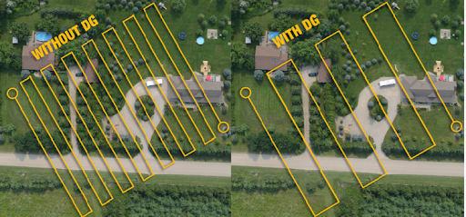
While 3D point cloud models can be created from 2D images, these structure-from-motion (SfM) algorithms falter among vegetation, water, power/phone lines and cell phone towers. LiDAR solves this problem by making direct range measurements to an object, which become 3D measurements using the position and orientation from a DG solution. Even better, combining a camera or hyperspectral imager with LiDAR produces the ability to “colorize” the point clouds for enhanced 3D information, or produce higher accuracy ortho imagery using LiDAR data to filter out distortions caused by foliage.
The essence of advanced DG technology lies in the consistent and reliable data it provides without ground-based reference points, which until recently were a staple in digital mapping. By marrying physical data to its precise location on the Earth’s surface, it’s quickly becoming the cornerstone of aerial mapping and surveying — allowing companies and even surveyors to anchor their measurements in the real world.
Taking accuracy and speed to new heights — just drag, drop and launch
GNSS signals from all available constellations help better counteract impact by multipath, signal diffraction or environmental obstructions. A sensor fusion approach of DG using aided-INS works no matter what a UAV encounters, which can be the difference between a successful mission and a costly headache. Furthermore, with advanced Trimble® RTX real-time and post-mission GNSS correction technology, centimeter-level mapping with UAVs — both in real-time or automatically upon landing — are now a reality.
A process that once demanded extensive time, manpower and financial resources is now a drag-and-drop, push-button process that doesn’t require a high degree of tech savvy to use.
An evolution fueled by GNSS and inertial tech — free from yesterday’s restraints
In essence, GNSS provides a constant stream of satellite data, pinpointing exact locations on the globe. When coupled with inertial tech, which tracks movement nonstop, the technology delivers a dynamic, precise understanding of a drone's position and orientation — leaving no stone unturned.
Turn today’s drones into mission-based tools
Beyond negating the hefty investment of time and resources associated with GCPs and base stations, the real magic of advanced UAV aerial mapping software unfolds in the air — where it executes projects with agility that slashes timelines and financial overheads. Moreover, the precision offered by this integration reduces error, minimizing the need for costly rework and adjustments.
Mapping hassles vanish into thin air
Looking forward, continued data processing advancements are primed to launch capabilities to further elevate accuracy, with the seamless integration of AI and machine learning that streamline the data analysis process, making it even more intuitive and insightful.
The agility, speed, and accuracy delivered by GNSS-INS tech from Trimble Applanix® make it a pivotal asset in any UAV aerial mapping toolkit that:
Mitigates human error and cuts the time and costs
Reduces the barriers to entry with subscriptions and “pay per use” options, making high-precision surveying accessible to a broader range of professionals
And redefines what can be achieved within geospatial exploration and data collection
Let us streamline your workflow
Trimble Applanix launched a new era of disruption earlier this year through a partnership with DroneDeploy, combining the Trimble POSPac™ Cloud post-processed kinematic (PPK) and positioning power from Trimble CenterPoint® RTX with the drone mapping and data collection capabilities of DroneDeploy’s reality capture platform. With our cloud positioning service, DroneDeploy’s customers can achieve a streamlined workflow and greater accuracy when performing reality drone capture.
The key advantages? No more base stations or dense ground control points are required. Our POSPac PPK engine generates the correct coordinates each and every time — taking time-consuming datum issues out of the equation. The easy-to-use cloud API enables the post-processing of GNSS kinematic positions based on dual-frequency observables logged by the drone and CenterPoint RTX.
What does all this mean for mapping?
Real-time and post-processed centimeter-level accuracy almost anywhere in the world
Corrections via satellite or cellular / IP — no base stations needed
Simplified workflows and a map provided within minutes of landing
Fixed global datum reducing time in the field, with no onsite setup
Cloud PPK solution always runs the latest, greatest software, opening doors for industries and applications such as construction, topography and temporal analysis
Why is PP-RTX in POSPac a game-changer?
Worldwide coverage, no base station or GCPs needed
Centimeter-level accuracy, approaching that of RTK
Reliable 24x7 monitored cloud service
User-friendly push-button or automated aerial mapping
Enhanced efficiency & productivity
Faster convergence time
Correction data can be logged in real-time (over-the-air corrections)
Data available within minutes after a UAV flight
Follow the leader
Not all DG solutions are created equal. Some use low-grade IMUs or work with inertial navigation solutions that haven’t been calibrated for survey and mapping work. Lean on Trimble’s legacy for solutions that stand up to real-world applications.
Learn more about how you can put our UAV mapping solutions to work for your unique application here.


