Harnessing the power of satellites to simplify the field layout process workflow

When it comes to laying out points quickly and accurately, the field layout for vertical buildings or large structures comes with its share of challenges and frustrations. Now, in addition to robotic or manual total station workflows, construction crews have an alternative powerful workflow to help streamline the process and effectively negate some of these challenges.
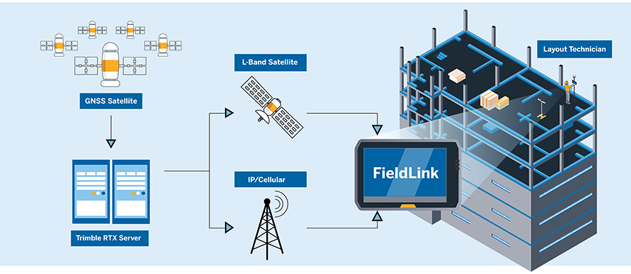
The growing availability of real-time networks and global GNSS correction services are ushering in a new era where base-rover workflows may take a backseat to faster and easier tools. These tools have the power to provide an ROI boost by way of enhanced efficiency and productivity.
Uncomplicate your layout tasks
Adopting new technology can be a daunting proposition especially when knowing that the current solution gets the job done. However, being aware of new approaches and methods can result in substantial gains in productivity, so it’s crucial to stay well-informed.
Robotic or manual workflows for layout have been the go-to for many years. And while these tools have their place, today’s contractors have more options for laying out critical infrastructure on a job site.
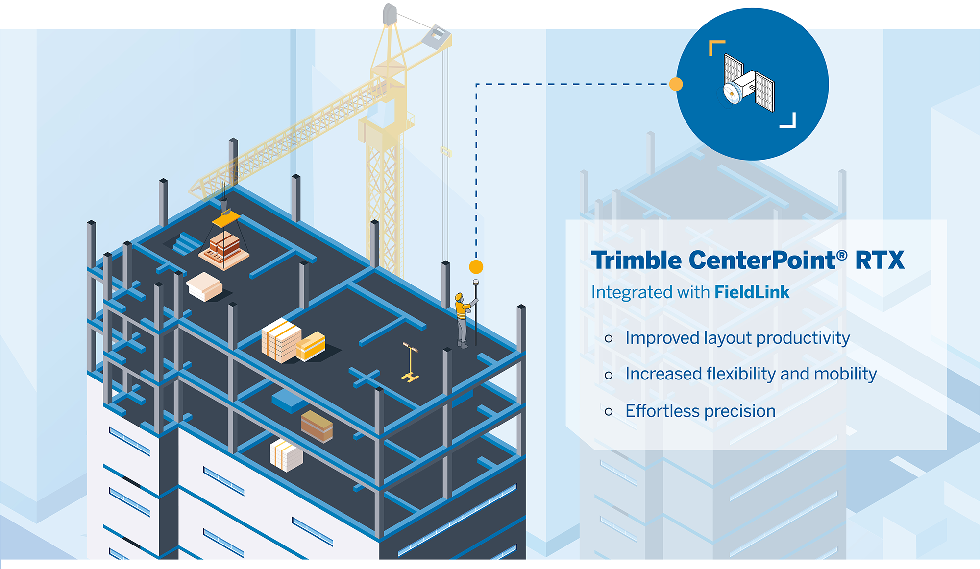
Adding GNSS corrections to your software unlocks a level of success that’s limitless as the sky above it. And since this critical work sets the pace for the success of an entire build, it’s worth a closer look.
Is it time to consider going base-less?
Adding GNSS corrections to your toolbox empowers crews with enhanced precision and productivity to tackle more complex tasks that are more cumbersome to complete with traditional tools. Trimble® provides a powerfully simple interface that transitions across all layout instruments for a flexible, scalable solution that performs 200% better than traditional workflows.
Trimble set out to design an efficient solution that:
Empowers your crews to boost layout productivity by harnessing precision GNSS and layout more points in less time without multiple setups, using a tilt-enabled receiver (R780 or SPS986)
Eliminates slowdowns caused by line-of-sight obstructions associated with robotic and manual workflows
Reduces planning complexities due to line-of-site requirements and allows you to move freely and streamline your workflow using the rover-only configuration, thus avoiding time-intensive base station setups
Ensures your points are correct the first time, and every time, with complete model visibility on the job site in real-time
Increases speed and efficiency in the field with one solution that manages the entire process
With GNSS, the construction layout is simplified. Unlike conventional methods, GNSS allows you to avoid the hassle of finding access to dependable control points as the project progresses and avoid the risk of error inherent in having to set control points in areas where work is ongoing. Measuring errors with CenterPoint® RTX remains consistently small throughout your job site.
GNSS corrections for field layout are ideal for both linear and vertical projects — anywhere where there’s sky above you. There are no line-of-sight struggles that are commonplace on worksites crawling with contractors, equipment or mounds of dirt.
On challenging job sites where a building sways or a deck is in constant motion from foot traffic or machinery, it can be challenging to find a secure location for your robotic total station. When using Trimble CenterPoint RTX with your GNSS receiver, you no longer have to worry about equipment on tripods or column clamps being disturbed or damaged by job site activities.