
The importance of enhanced accuracy in hydrographic surveying
Accurate data is in high demand. Marine navigation and construction rely on precise depth measurements and seafloor mapping. While onboard sensors deliver relative accuracy, integrating satellite technology and employing GNSS provides absolute accuracy, ensuring exact real-world positioning. Any inaccuracies during the survey can propagate through the system, compromising survey results and leading to costly errors in project design and implementation. Accurate, directly georeferenced data can be achieved through various methods.
Beyond boundaries: Real-time GNSS corrections for surveying excellence
With over a decade of expertise in delivering high-accuracy precise point positioning (PPP) solutions on land, Trimble® Positioning Services has established itself as a leader in GNSS corrections.
Trimble RTX® is a PPP technology that uses Trimble's global network of reference stations to accurately generate state space representation models of the ionosphere and troposphere. In addition, accurate GNSS satellite ephemeris data is utilized to mitigate clock and orbit biases.
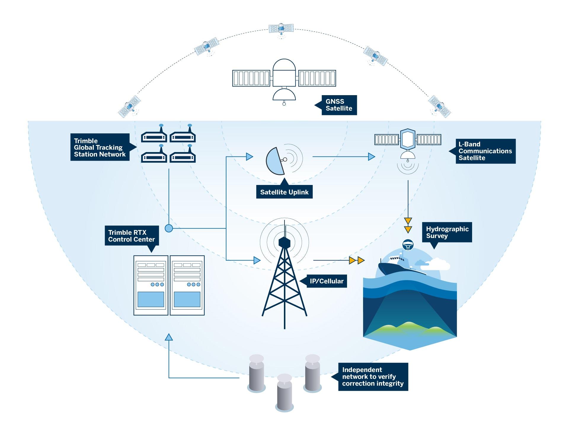
Illustration: How Trimble’s PPP solution works
Trimble RTX is available over the Internet or via L-band from geostationary satellites. The independent Trimble RTX integrity network checks and assures the availability and accuracy of the Trimble RTX correction data. The result is a dependable real-time correction service that you can count on for your precise surveying.
Recently, Trimble leveraged its extensive experience and expanded this proven technology to the marine, introducing the CenterPoint® RTX Marine correction service. Although a later entrant to this market, CenterPoint RTX Marine quickly distinguished itself and set new standards with industry-leading horizontal and vertical accuracy, fastest convergence times, global availability and advanced security features.
Impact of real-time accuracy in hydrographic surveying
One key feature of the PPP technology is delivery of data in real-time. This capability goes beyond merely meeting the demands of hydrographic surveying; it anticipates and addresses these needs as they arise, ensuring a proactive approach to challenges.
Consider a typical project surveying a seabed for new port construction. Relying solely on post-processing data is risky. Missed areas from a float solution could lead to data rejection later in the office, necessitating a re-survey of portions of the work. Utilizing reliable, real-time corrections means data accuracy is observed during the survey, minimizing the risk of re-surveying and thereby saving time and resources.
Numerous maritime applications benefit from access to immediate data
Hazard reporting: Some commercial companies, as part of their operations, submit updated navigation data to agencies like the Maritime Coast Guard Agency (MCA) and the Civil Hydrography Program (CHP). Real-time data allows surveyors to report potential hazards within 24 hours, supporting safer and more accurate chart updates.
Marine construction: Projects may involve cable and pipeline route surveys or turbine and subsea assets installations. Real-time positioning ensures decisions can be made swiftly and that assets are placed with high precision, directly impacting safety on-site.
Dredging operations: Dredging relies on constant updates to accurately track progress. Real-time corrections enable machines to receive the latest progress data, ensuring operations move forward without delay. Precision here is also crucial for volume calculations and meeting specifications for factors like standard deviation and sounding density.
Geophysical applications: Real-time data is critical for seismic mapping, resource exploration, and environmental monitoring, ensuring that geophysical data is accurately aligned with spatial coordinates, improving the results' reliability and timely decision-making.
Post-processed data vs. real-time data: What’s the difference?
Real-time and post-processing methods are often combined, however depending on the specific survey requirements there may be a choice between the two.
Raw data collected during the survey that is analyzed, edited or cleaned afterward is called post-processed data. A workflow that integrates post-processing offers the ability to enhance accuracy by overcoming issues associated with real-time operations, like correction of telemetry outages. In hydrographic surveying, this step ensures that the multibeam sonar data meets stringent quality standards before final analysis and is essential for achieving high-accuracy results.
Real-time data, on the other hand, requires the use of an external real-time correction source to achieve centimeter-level accuracy and align multiple data streams immediately during collection.
As a satellite-delivered solution, PPP technology delivers untethered operations removing the need for a base station and its associated hardware, or the restrictions associated with baseline length. Overlapping satellite beam footprints and multiple delivery methods (L-band and NTRIP) provide a level of redundancy and robustness, which is vital for real-time operations.
The ability to use real-time data, while also having the option for post-processing, ensures that data meets the highest standards of accuracy.
Make reliability your position
Hydrographic surveyors face a wide array of challenges, as complex and varied as the environment in which they operate. The continuous pursuit to enhance efficiency and ensure safety is essential in this demanding field.
With the introduction of CenterPoint RTX Marine, Trimble now provides hydrographic surveyors with a comprehensive positioning solution that integrates hardware, software, and GNSS correction services. Designed for ease of use and efficient deployment, this solution is built on a foundation of dependable precision, enhancing both the accuracy and reliability of surveying operations on water.
Learn more about CenterPoint® RTX Marine.


